
By today, we have certainly earned our polka dot jersey, or ‘maillot à pois rouges’, that the King of the Mountains wear at the Tour de France.
But first things first. The night was extremely cold. This morning shortly before six, I woke up being cold. The thermometer inside my roof top tent read 6.2°C. Brrrrr! Although I had taken precautions and was wearing three layers as well as socks inside my sleeping bag and closed all windows to keep the cold air out, it was still freezing cold and I had outside temperature inside my roof top tent. Afterwards, I didn’t really sleep anymore until my alarm went off at seven. With these temperatures I really didn’t want to leave my sleeping bag, get down, get washed and dressed, but a man has to do what a man has to do. 😉
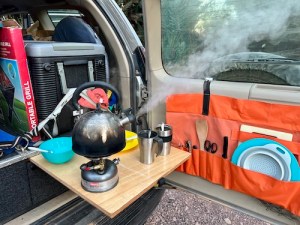
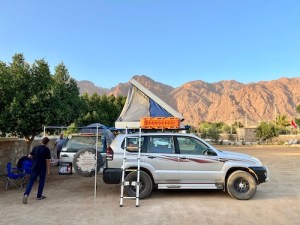
Same ritual as every day, breakfast in between packing up the vehicles and this time also chatting to Mark while trying to swiftly upload the blog with pictures. We managed in the end and left waving at Mark at half past eight.
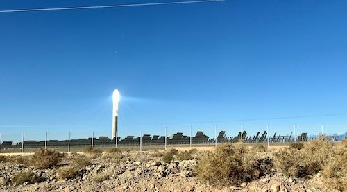
Trevor had expressed the wish to see the Ouazarzate Solar Power Station (OSPS), also called Noor Power Station, a bit more closely. He had found out, that you could actually visit it, but that needed to be arranged at least a month in advance. That time we didn’t have. A glance at the map indicated, that there is actually a road running parallel to the photovoltaic part and the concentrated solar power part. We decided to try this road to get a better view of this famous power plant. It meant, however, a detour to the other side of town of about 60km. We reached the turn off to the parallel road from the National Road 10. High voltage power lines everywhere. It was immediately evident, that it was well guarded by military, as they had a base on the southern side and watch posts every couple of hundred meters along its sides. We drove further up the parallel road and got a good view of both parts, the photovoltaic one as well as the gigantic 250m high tower, called the receiver. The receiver glares so brightly that it blinds you, being just near it. This enormous structure collects the sun rays with mirrors, that move with the sun, to generate heat that drives a heat engine connected to an electrical power generator. With its 510MW it is the world’s largest of its kind. The additional photovoltaic installation produces 72MW. The entire project’s estimated cost is around 2.5 billion USD and covers 2,500 hectares. Very impressive to see. We didn’t dare to stop to take pictures, so we shot a few out of the car window while driving slowly. Once done, we headed back to town and were finally on our way to today’s destination.
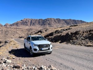
After a few kilometres on the road towards Marrakech, we turned South towards Tazenakht driving through many wide valleys and crossing a few mountain ridges. The scarce vegetation and landscape reminded me a bit of the Karoo in South Africa.
Once reached, the road then lead us West to Taliouine. Here we tried to buy some bread, that, however, proved to be difficult as apparently two bakers had decided not to work today. But Brahim prevailed and found us some bread in town for lunch. We were now at the edge between the end of Atlas Mountains and the beginning of the Anti-Atlas Mountains. Again our route followed valleys and crossed hills and mountains. The landscape was bare and rocky. Actually hostile. Not much green to be spotted. Once in a while we saw a few black goats trying to find something to feed of, but that was it. So far, we saw a bit of traffic and a few foreign registrations. Just outside Talioune, we found a nice argan tree next to the road and stopped in its shadow for lunch.
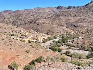
Afterwards, we reached the small mountain village of Assaki and left the national road. This new road brought us into a very remote area of the Anti-Atlas Mountains I had not been before. Immediately, it became clear, this area must also have been affected by the earthquake three months ago. Because in the first villages we saw a few tents set up in front of houses. What stroke us, however, was that we did not see any damage to any of the buildings. None destroyed, collapsed or even cracks in the outside walls. Nothing. Why were the tents there?
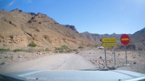
Almost the first ford we wanted to cross, showed signs of flood damage. The next ford had been washed away completely. Road signs had been set up permanently warning us of road narrowing, speed limits and detours. The further we drove into the valley, the more destruction we saw to the road and fords. Many were heavily damaged that a detour lead you through the riverbed. That slowed us down, but mad the trip extra special and adventurous.
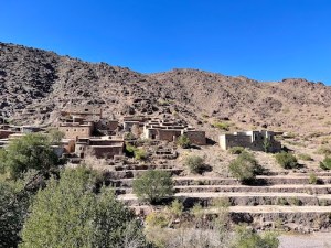
This valley is beyond any tourist route and the villages often as original as you can still get them. Many old mud houses with their mud roof were still intact and inhabited. We stopped a few times to snap a pictures but did not want to disturb the villagers. Sometimes kids immediately came running towards us. We usually got moving again before they could reach us. It became evident that a massive wave of water must have raced through this valley and took a lot of infrastructure with it. That must have happened already many many moons ago as the signs had already been placed on a permanent basis and plants had started growing out of the destroyed fords.
We felt a bit like discovering a new world and crawled further towards the upper parts. The few villages that were in this valley nestled between the mountain walls and the riverbed with not much room to spare.
Along the way, numerous patches of land that once used to be plantations of almond and argan trees, were now all dry and often reduced to the trunk only. The drought of the past couple of years has caused havoc here. Farmers had to give up their livelihood, as it became no longer viable.
We crossed over more ridges and hills. The frequent sharp bends can make you start feel nauseous, as well as start feeling monotonous and you are no longer highly concentrated. Not a good combination.
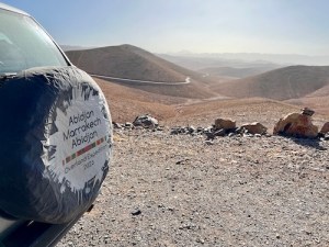
We have crossed again many, many mountain passes today. Anything from just above 1,000m to way over 2,400m. We finally conquered our final pass, stood on top and looked at a golden hazy panorama. This air is typical for the Anti-Atlas as the desert sand dust gets picked up and transported through the air for miles.
We also asked ourselves, where was our polka dot jersey? With so many mountain road and track kilometres and mountain passes, all the way up to 3,005m, we had certainly deserved one jersey each!
A few kilometres to our destination today: Tafraoute. We decented into town and straight to the camping I had chosen. What we saw, we didn’t like. Half the camping was full of large French motor homes with very little shade and space for us. We, as quickly as we came and went to the alternative. That ones seemed to be abandoned as the gates were open, no caretaker and no customers. Ok. A new alternative was promptly found in the suburb. After a quick check, we decided to stay here for the next two nights. We found one other camper van from Germany with a lady and her small daughter. After some discussion, we arranged our cars to be able to set up camp and tents. Again we were welcomed in different languages, preferably in German or English. French was not preferred.
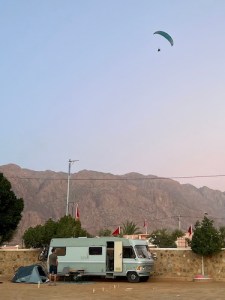
Later, I a Dutch family of five arrived in a at least thirty year old Mercedes camper van. They setup camp across from us. At a certain point all eyes went skyward. A paraglider flew circles above the camp and finally landed across on the other side of the street. It turned out to be the husband of the German lady with her daughter, who shouted happily “Papi, Papi!” And ran towards the landings site.
Tonight our camp kitchen stayed cold and we ordered tajines with Harira as a starter at the restaurant which were very good.

You must be logged in to post a comment.